
previous next
Click here to return to the main page of elevation profiles
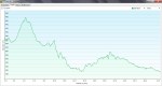
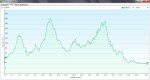
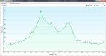
Here are the daily elevation profiles created with my Garmin 62s GPS.
NOTE:
-
There is no day 6, as this was my rest day in Tomar.
-
The height is measured in metres and the distance in kilometres.
-
Don’t forget you can click on any picture to enlarge the graphs so you can see the details.
-

- Day 1, Lisbon to Vilafranca de Xira
-

- Day 2, Vilafranca de Xira to Azambuja
-

- Day 3, Azambuja to Santarem
-

- Day 4, Santarem to Golega
-

- Day 5, Golega to Tomar
-

- Day 7, Tomar to Alvaiazere
-
- Day 8, Alvaiazere to Rabacal
-

- Day 9, Rabacal to Coimbra
-

- Day 10, Coimbra to Mealhada
-

- Day 11, Mealhada to Agueda
-

- Day 12, Agueda to Oliveira de Azemeis
-

- Day 13, Oliveira de Azemeis to Grijo
-

- Day 14, Grijo to Porto
-

- Day 15, Porto to Vilarinho
-

- Day 16, Vilarinho to Barcelos
-
- Day 17, Barcelos to Ponte de Lima
-
- Day 18, Ponte de Lima to Valenca
-

- Day 19, Valenca to Mos
-

- Day 20, Mos to Pontevedra
-

- Day 21, Pontevedra to Caldas de Reis
-

- Day 22, Caldas de Reis to Herbon
-

- Day 23, Herbon to Santiago de Compostela

This looks really useful. Have put a link on my camino Facebook page.
https://www.facebook.com/trepidatioustraveller
LikeLike
Thanks Maggie, I’ll update my blog this week with profiles for the other walks as well.
LikeLike
Hello
I’m thinking of mountain biking the Portuguese route in May, I’ve done 2/3 rds of the Frances route (off-road, not the road route some tourers follow) and there’s some big climbs! From your elevation maps, the Portuguese route doesn’t seem too bad, how do to the two routes compare? Is second half of May a good time to start, weather wise? Appreciate you walked, but did surface seem mostly bikeable and did you see many cyclists en route? Were there many hostels and/or opportunities to camp? Sorry for all the questions, would value your feedback!
Richard
LikeLike
Hi Richard,
Can I just ask where you’re planning to start, Lisbon or Porto? And if you think you’d like to continue along the central route from Porto to Santiago or the coastal route? This will help me answer your questions 🙂
LikeLike