
24th November, 2019
- Day 15: Belos ruins to Mavikent
- Distance: 28.2km
- Ascent / Descent: 90m / 970m
- Weather: sunny, 20 degrees C
- Accommodation: wildcamp in Mavikent
- Total cost for one (Turkish Lira ₺): transfer to Belos ruins 75, breakfast at cafe in Finike 31, resupply at market in Mavikent 8 = ₺114 (~£14 / €17 / US$19)
At 7am, we leave the pension for the last time, driven by the owner Salih. He drops us off at Belos ruins in the same spot as he did two days ago, however this time, we walk downhill towards Finike. It feels nice to be walking in the ‘right’ direction again; I must admit I’ve found the past couple of days a little stagnant with pre-organised stages and finishing in the early afternoon.
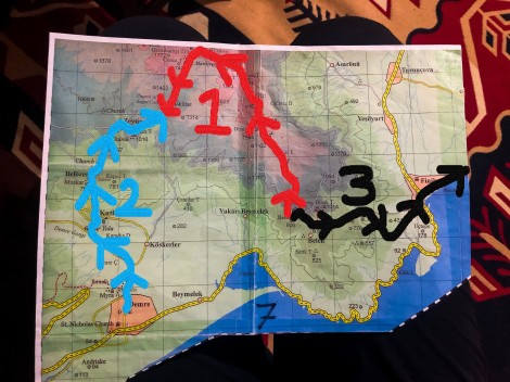
We’re on the final section today, the black ‘3’

8:42am – only 4km to Finike, this should be a breeze…
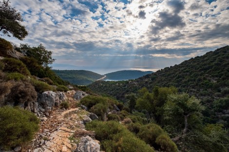
We follow a dirt road briefly before veering off downhill on a rocky trail. Believing it’s only 4km to the town of Finike, I mistakenly think we’ll be there in no time, but this is not the case! After a few switchbacks, the trail follows a dry riverbed and as it’s still early, the rocks are slippery with the morning dew. It’s very slow-going under the weight of our full packs, as we carefully place each step.

8:55am – descending from Belos to Finike

9:18am – following a dry riverbed

9:34am
10:26am – these 4km are taking forever!
Finally we reach a dirt road and follow this downhill onto a sealed road into Finike. I look at the app and realise we’ve walked 9km to get here (not 4!) and it’s taken three hours. (The ‘4km to Finike’ road sign was obviously if you followed the road, not the Lycian Way!) Reaching the main road, D400, we stop for breakfast at the first cafe we pass. It just happens to be quite a fancy place too and much to my delight, they serve Baklava and coffee!
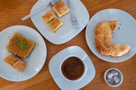
11:29am – break time at the fanciest café in Finike (and the first one we tried!) Happy as Larry to be having baklava for breakfast 🙂
We’ve been recommended to take a dolmus between Finike and Karaöz instead of walking. We’re told (by the pension owner) it’s 17km of walking along a pebble beach. From reading other blogs and even the guidebook, it appears most people do skip it. We’re going to walk it and find out for ourselves.

12:23pm – we were recommended not to walk the section between Finike and Karaöz (a pebble beach apparently) so this pavement is a welcome surprise
Picnic anyone?
Considering our expectations of walking along pebbles, we’re delighted to find a dedicated pedestrian path for the first kilometre (pics above) and then a pedestrian and cycle path beside the D400 for the next 10km. Yes it’s flat and monotonous and beside the highway, but after all the rocky trails of the Lycian Way, it’s a welcome treat!
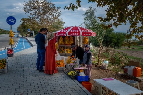
12:51pm – yes, we’re now beside the main highway but there’s still a dedicated pedestrian footpath and the chance to buy fruit
We turn off the highway on the outskirts of Mavikent and follow a smaller road passing numerous greenhouses. The area is different to any we’ve seen so far; the houses are built on stilts, there’s barking dogs everywhere and it feels a little more ‘edgy.’ I wonder if this is also the reason we’ve been recommended to take a dolmus all the way to Karaöz?

3:26pm – how misleading photos can be… this dog scared the crap out of me with its incessant barking

3:56pm – passing greenhouses in Mavikent
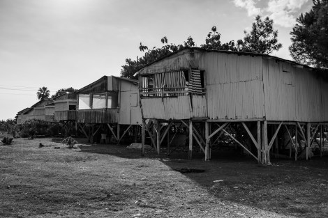
We pass many of these stilt houses in Mavikent (the first time to see them on the trip)
Realising there’s not much daylight left and Mavikent is a bit of a black hole for accommodation, we stock up on bread at a market and search for somewhere secluded to wild camp. We find a forested area but it’s a little unnerving to see piles of empty alcohol bottles and car tracks everywhere so we head deeper into the vegetation until we’re well and truly out of sight.
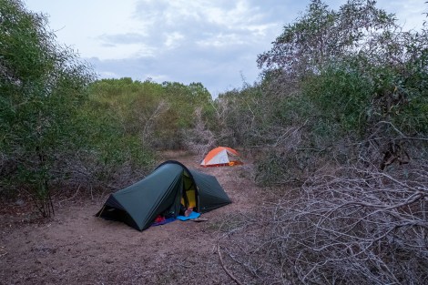
5:48pm – our stealth camp for the night

Lycian Way – route information by Komoot – day 15
We’re using Komoot* for navigation and to record our own tracks. Prior to departing the UK we uploaded the GPX tracks to Komoot so we can now use them for navigation (with voice commands). We’re also using Komoot to record our own daily tracks which gives us the above maps, elevation profiles, distance, speed etc. You can find our collection of tracks on the Komoot App by searching ToughGirl for Sarah and followingthearrows for me. Or click the link in the caption on the above map to go straight to the track.
*Komoot premium was gifted and we also received sponsorship for this hike.
To see Sarah’s vlogs of our Lycian Way hike, click here. You can also follow her on Instagram, Twitter, LinkedIn, YouTube, and keep up to date with the Tough Girl podcasts here.
If you have any questions, leave me a comment and I’ll add a FAQ post at the end of the trip.
