
previous next
Click here to return to the main page of elevation profiles
Here are the daily elevation profiles created with my Garmin 62s GPS.
NOTE:
-
There appears to be some kind of glitch with Day 1 and the graph is NOT correct until after km 8. (I started almost at sea level and started climbing up, not down)
-
There is no day 9, 10. 11 or 12 as these were rest days in Lugo.
-
The height is measured in metres and the distance in kilometres.
-
Don’t forget you can click on any picture to enlarge the graphs so you can see the details.
-
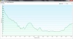
- Day 1, Oviedo to San Juan de Villapanada NOTE: This is NOT correct until after km 8, the walk was a climb up, not down for the first 8 km
-

- Day 2, San Juan de Villapanada to Bodenaya
-

- Day 3, Bodenaya to Campiello
-

- Day 4, Campiello to Berducedo
-

- Day 5, Berducedo to Grandas de Salime
-

- Day 6, Grandas de Salime to Fonsagrada
-

- Day 7, Fonsagrada to Castroverde
-

- Day 8, Castroverde to Lugo
-

- Day 13, Lugo to San Roman da Retorta
-

- Day 14, San Roman da Retorta to Melide
-

- Day 15, Melide to Salceda
-

- Day 16, Salceda to Santiago de Compostela
