
previous next
Click here to return to the main page of elevation profiles
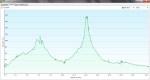
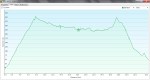
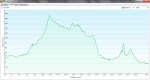
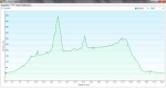
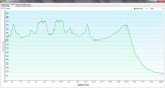
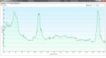
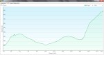
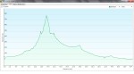
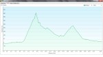
Here are the daily elevation profiles created with my Garmin 62s GPS.
NOTE:
-
There is no Day 29, 32 or 44 as these were rest days, and no Day 20 or 28 due to human error, sorry!
-
The height is measured in metres and the distance in kilometres.
-
Don’t forget you can click on any picture to enlarge the graphs so you can see the details.
-

- Day 1, Temples 1-5
-
- Day 2, Temples 6-10
-

- Day 3, Temples 11-12
-

- Day 4, Temples 13-17
-

- Day 5, Temples 18-19
-

- Day 6, Temples 20-21
-

- Day 7, Temple 22
-

- Day 8, Temple 23
-

- Day 9, No Temples (Tebajima Guesthouse)
-

- Day 10, Bangai Temple 4
-

- Day 11, No Temples
-

- Day 12, Temples 24-26
-

- Day 13, Temple 27
-

- Day 14, Temples 28-29
-

- Day 15, Temples 30-31
-

- Day 16, Temples 32-35
-

- Day 17, Temple 36
-
- Day 18, Temple 37
-

- Day 19, No Temples (Shimanto city)
-

- Day 21, Temple 38
-
- Day 22, Temple 39
-

- Day 23, Temple 40
-

- Day 24, No Temples (Uwajima)
-
- Day 25, Temples 41-43
-

- Day 26, No Temples (Kumokogen)
-
- Day 27, Temples 44-45
-
- Day 30, Temples 52-53
-

- Day 31, Temples 54-55
-

- Day 33, Temples 56-59
-

- Day 34, Temples 60-64
-

- Day 35, No Temples (Iyo Misuima)
-
- Day 36, Temples 65-66
-

- Day 37, Temples 67-70
-

- Day 38, Temples 71-75
-

- Day 39, Temples 76-79
-

- Day 40, Temples 80-83
-

- Day 41, Temples 84-86
-
- Day 42, Temples 87-88
-
- Day 43, Back to Temple 1
-

- Day 45, Choishimichi to Koyasan
⇒ Planning for the Shikoku 88 Temple Pilgrimage
⇒ Blogging from the Shikoku 88 Temple Pilgrimage
⇒ Gear List
⇒ Expenses – How much did it actually cost?
⇒ Video Gallery
