
previous next
Click here to return to the main page of elevation profiles
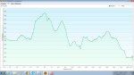
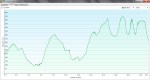
Here are the daily elevation profiles created with my Garmin 62s GPS.
NOTE:
-
The height is measured in metres and the distance in kilometres.
-
Don’t forget you can click on any picture to enlarge the graphs so you can see the details.
-

- Day 1, St Bees to Ennerdale YHA
-

- Day 2, Ennerdale YHA to Borrowdale
-

- Day 3, Borrowdale to Grasmere
-

- Day 4, Grasmere to Patterdale
-

- Day 5, Patterdale to Shap
-

- Day 6, Shap to Kirkby Stephen
-

- Day 7, Kirkby Stephen to Keld
-

- Day 8, Keld to Reeth
-
- Day 9, Reeth to Richmond
-

- Day 10, Richmond to Danby Wiske
-

- Day 11, Danby Wiske to Osmotherley
-
- Day 12, Osmotherley to Chop Gate Clay Bank Top
-

- Day 13, Chop Gate Clay Bank Top to Grosmont
-

- Day 14, Grosmont to Robin Hood’s Bay

Kat,
What software do you use for your elevation profiles?
I use GPX tracks but always struggle creating these cleanly.
Regards,
Wayne.
LikeLike
Hi Wayne,
I use a Garmin GPS and Basecamp software (what it comes with), then copy and paste the profile to paint and save as a jpeg file. I’m sure there’s an easier way that could save a ton of time but I haven’t found it yet!
LikeLiked by 1 person
Hi Kat
I am working out a plan to do Wainwright’s Coast-to-Coast later this year. Any chance you could add your 14 .GPX files to this site? When I have finished I would happily email you my .GPX files in return.
Thanks anyhow, handy to see profiles for your walk.
LikeLike
Hi Frank,
Sorry for the delayed reply, I’m out walking and don’t have access to the gpx files but I downloaded the tracks from the Trailblazer guidebook which was a terrific resource and highly recommended. Have a great walk!
LikeLike