
previous next
Click here to return to the main page of elevation profiles
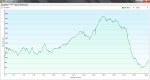
Here are the daily elevation profiles created with my Garmin 62s GPS.
NOTE:
-
The height is measured in metres and the distance in kilometres.
-
Don’t forget you can click on any picture to enlarge the graphs so you can see the details.
-

- Day 1, Wallsend to Heddon-on-the-wall
-
- Day 2, Heddon-on-the-wall to Humshough
-

- Day 3, Humshough to Gilsland
-

- Day 4, Gilsland to Carlisle
-

- Day 5, Carlisle to Bowness-on-Solway
