
熊野古道

Kumano Kodo wooden marker

Kumano Hayatama Taisha to Nachi waymarks

Kumano Kodo waymarks painted on the road between Nachi station and Daimonzaka
The Kumano Kodo is a network of ancient pilgrimage trails linking the former capitals of Kyoto and Nara to three sacred sites in the mountainous, rugged and exceptionally scenic Kii Peninsula:
-
Kumano Sanzan – made up of three grand shrines: Hongu Taisha, Hayatama Taisha and Nachi Taisha in the Kumano area.
-
Koyasan – Mt Koya is the birthplace of the Shingon sect of esoteric Buddhism under Kobo Daishi (Kukai).
-
Yoshino & Omine – Mt Omine and it’s mountain-top temple Ominesan-ji are considered holy sites of the Shugendo sect of Buddhism and a training ground for these mountain Buddhists. Surprisingly, still today, women are banned from climbing Mt Omine.
In 2004, these three sacred sites and the pilgrimage routes that connect them were given Unesco World Heritage Status under the title, “Sacred Sites and Pilgrimage Routes in the Kii Mountain Range.”
These sacred sites and the connecting trails “reflect the fusion of Shinto, rooted in the ancient tradition of nature worship in Japan, and Buddhism, which was introduced from China and the Korean Peninsula. The sites (495.3 ha) and their surrounding forest landscape reflect a persistent and extraordinarily well-documented tradition of sacred mountains over 1,200 years.” – Unesco site
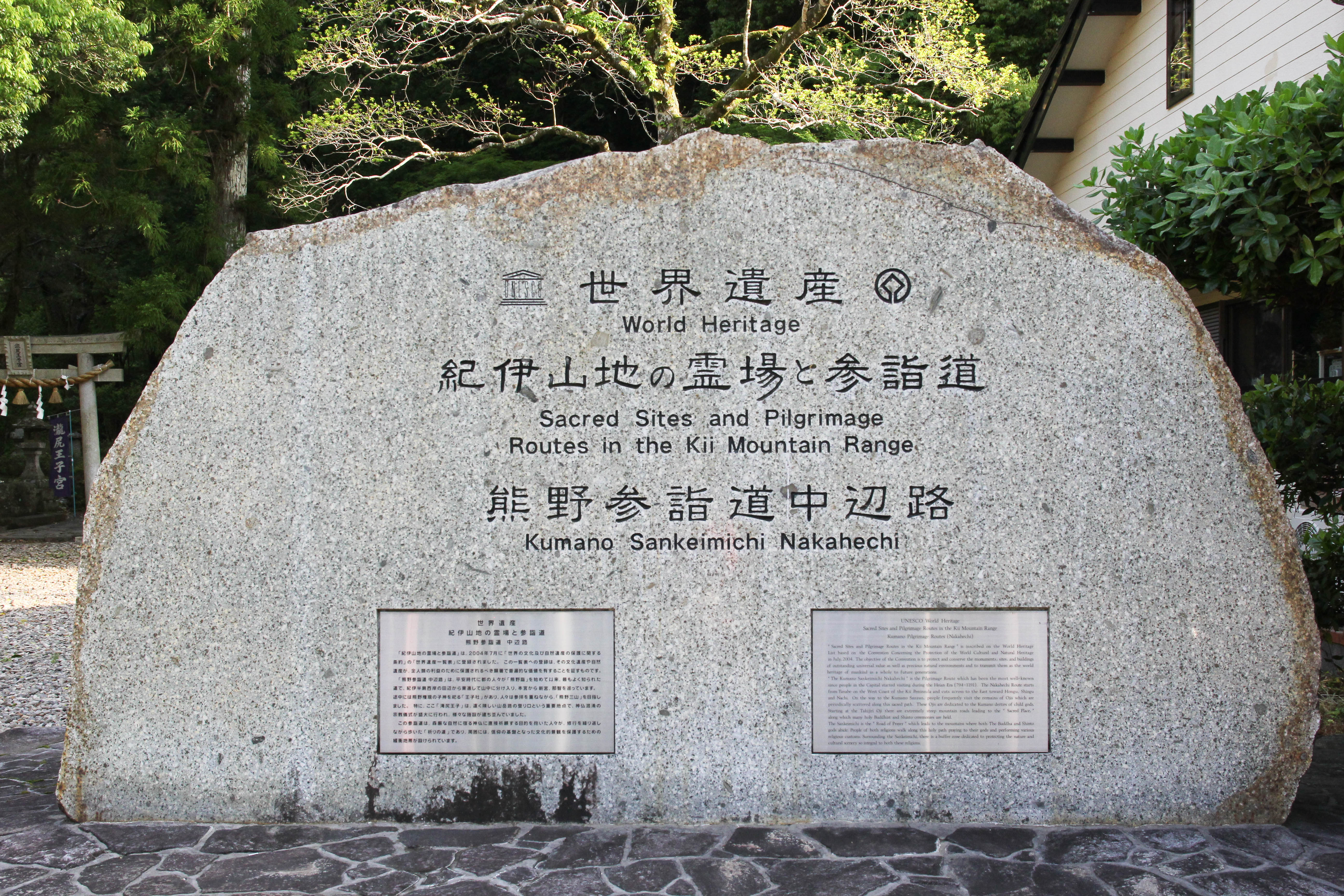
Sacred Sites and Pilgrimage Routes in the Kii Mountain Range
The ancient pilgrimage trails connecting these 3 sacred sites are:
-
Nakahechi – Traditionally, once pilgrims from Kyoto and western Japan reached Tanabe on the west coast of the Kii Peninsula, they would join the Nakahechi route and travel east to Hongu Taisha, then travel by boat down the Kumano river to Hayatama Taisha and then walk west to Nachi Taisha, thus visiting the three grand shrines of Kumano, otherwise known as the Kumano Sanzan.
-
Kohechi – the shortest route linking Hongu and Koyasan, the Kohechi is a 70km north-south mountainous trail traversing 3 peaks over 1,000m.
-
Choishimichi – this 24km trail from the base to the top of Mt Koya was built by Kobo Daishi and is called ‘Choishimichi’ after the stone markers (choishi) placed at intervals along the trail. This trail is also included in the World Heritage listing.
-
Omine Okugake – considered the hardest of the pilgrimage trails, this trail links Hongu with Yoshino and was used as a training ground by Shugendo monks.
-
Iseji – a 170km trail linking Ise Shrine in Mie prefecture with Hayatama Shrine and the Kumano Sanzan in Wakayama prefecture.
-
Ohechi – a 130km coastal trail linking Tanabe with Nachi.
For an overview map of the routes, see Tanabe City Kumano Tourism Bureau and Visit Wakayama

Early morning rays on the Kogumotori-goe trail

Nakahechi trail

Tree-root trail!

Moss-covered stone path along the Nakahechi

Stone lantern along Daimonzaka

First view of Hongu from Fushiogami-oji
Follow me as I walk the Nakahechi, Kohechi, Choishimichi, Nyoninmichi, Iseji and Ohechi routes.
A huge thanks to Brad and the team at the Tanabe City Kumano Tourism Bureau for all of their help and terrific website.

Hayatama Taisha Grand Shrine

Nachi Taisha Grand Shrine

Hongu Taisha Grand Shrine

Looking forward to your daily entries. Eager for some more details! When, how long, how far? Best of luck on your new adventure!
LikeLiked by 1 person
Stay tuned, it’s going to be awesome! 😉
LikeLike
Amazing….how wonderful!
LikeLiked by 1 person
I love when you start prepping for adventures, look forward to following along!
LikeLiked by 1 person
Thanks!!
LikeLike
Wow! What a walk! Enjoy every step! X
P.S. Getting itchy feet 😉
LikeLiked by 1 person
Oh, yay! I am excited to follow you on another adventure.
LikeLiked by 1 person
Thanks!
LikeLike
I’m loving your daily updates! I’m really drawn to doing the Kumano Kodo, but speak no Japanese. What do you think about someone doing this hike with no Japanese language?
LikeLike
Thanks! The Nakahechi route is the most popular route and I met heaps of foreigners on it (who didn’t speak Japanese) and they were doing just fine – there are English maps and English signs. It might still be a challenge, but that’s part of the adventure 😉
LikeLike
Do you think this route is possible for someone who does not speak any Japanese?
LikeLike
The Nakahechi route absolutely. The other routes are possible too but will just be more challenging!
LikeLike
Hi 🙂 thank you for your blog! I love reading your adventures!
I’m planning on doing the Iseji route in April next year and was wondering whether you required water treatment for drinking tap water along the way?
Thanks!
LikeLike
Hi Hannah,
Lucky you!
Tap water from houses etc is fine and you’ll find a vending machine or two in every village you pass through. You might want to treat the water if you’re getting it from spouts in the mountains, my stomach isn’t as strong as it used to be, so I never filled up in the mountains (and didn’t need to on that trip either).
Have a great time!
LikeLike
Excellent! 🙂
Thankyou so much!!
I’m using your itinerary as a guide for my trip.
So, I really appreciate how detailed you’ve logged your days! 🙂
LikeLike
That’s great! There’s no waymarks on the Iseji route though, can you read and speak Japanese to follow the Japanese sketch map?
LikeLike
Haha. No.
I do not speak or read any Japanese..
I’m teaching myself some at the moment.. but, do you think it’s going to be an issue? 😑
LikeLike
Hi Hannah,
There’s no waymarks on that route and the sketch map is in Japanese so it might be quite challenging without being able to read/speak Japanese. Have you looked at the Nakahechi route? The Nakahechi has bi-lingual signs and a good network of accommodation too.
LikeLike